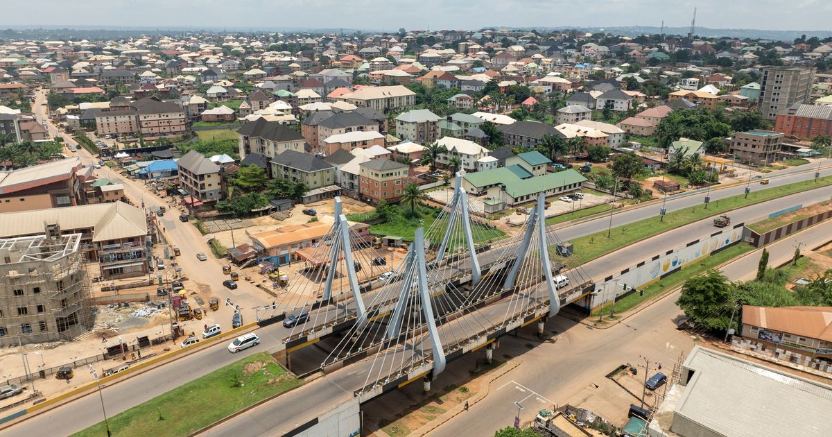
Anambra State, the Light of the Nation, is one of the most densely populated and entrepreneurial states in Nigeria. Home to the vast commercial city of Onitsha and the industrial powerhouse of Nnewi, it embodies the trading and manufacturing genius for which the Igbo people are famous across Africa and the world.
This complete guide brings together everything you need to know about Anambra State in one place: the full postal (zip) code for every local government area, the codes for its major towns, and an in-depth profile covering the capital, government, economy, infrastructure, education, culture, tourism and climate.
Before we get to the codes themselves, it helps to understand what they are. In Nigeria, what many people casually call a “zip code” is officially known as a postal code. These are the six digit numbers managed by the Nigerian Postal Service (NIPOST) that identify a specific area for the sorting and delivery of mail. Whether you are sending a parcel, filling out an online form, registering for a service or verifying an address, using the correct postal code for your location keeps everything accurate and reliable.
Anambra Zip Code
The postal (zip) codes of Anambra State range from 420001 to 435115. The state has 21 local government areas, each with its own code, and the capital Awka falls under 420102 to 420281. Because Anambra State is large and every district can have its own code, no single number covers the whole state.
This is why it is always best to confirm the exact code for your specific location rather than relying on one general figure. The tables further down this page list the code for every local government area and for the major towns of the state, so you can find the one that matches your address.
How Postal Codes Work in Anambra
Nigeria’s postal code system uses six digits, and the numbers are not random. The opening digits point to a broad postal zone and district, while the remaining digits narrow the location down to a specific delivery area. In Anambra State, the codes are grouped around the capital Awka and spread outward across the local government areas and towns.
For everyday use you rarely need to memorise these codes. What matters is knowing where to look them up and making sure you use the code for your exact district, since a parcel addressed with the wrong postal code can be delayed or misrouted.
As a simple example, a letter or package addressed to the capital, Awka, would carry a code in the 420102 to 420281 range, while an address in one of the more distant local government areas would use a completely different code. The tables below list the ranges recorded against each local government area and major town in the state, which will get you to the right part of the numbering. They are a starting point rather than the last word: the code that matters for an official form is the one used by the post office that actually delivers to the address.
Full List of Anambra State LGA Postal Codes
Below is the complete list of all 21 local government areas in Anambra State and their postal (zip) codes.
How to read this table. NIPOST assigns postal codes to post office delivery districts, not to local government areas, and the two do not line up neatly. One delivery district often serves parts of several LGAs, which is why neighbouring areas here can share the same range — that is the system working as designed, not an error. Treat a range as the codes covering that area, not as a code issued exclusively to it. Where a code has to be exact, confirm it with the post office that delivers to the address before you submit anything.
Local Government Area (LGA)
Postal Code Range Serving This Area
Aguata
422111
Anambra East
432101 to 432108
Anambra West
432109 to 432115
Anaocha
422101 to 422110
Awka North
420111 to 420281
Awka South
420102 to 420110
Ayamelum
433108 to 433115
Dunukofia
421107 to 421112
Ekwusigo
435112 to 435115
Idemili North
434101 to 434110
Idemili South
434111 to 434117
Ihiala
431116 to 431125
Njikoka
421101 to 421106
Nnewi North
435101
Nnewi South
435102 to 435113
Ogbaru
431101 to 431115
Onitsha North
430001 to 430282
Onitsha South
430212 to 430283
Orumba North
423116
Orumba South
423101 to 423115
Oyi
433101 to 433107
Postal Codes of Major Towns in Anambra
These are some of the most searched towns and areas of the state and their postal codes.
Major Town
Postal Code Range Serving This Area
Awka
420102
Onitsha
430001
Nnewi
435101
Ihiala
431116
Ekwulobia (Aguata)
422111
Aguleri (Anambra East)
432101
Major Cities and Towns in Anambra State
Awka, the capital, is the administrative centre of the state, historically famous for its blacksmiths and now home to the machinery of state government.
Onitsha, on the bank of the River Niger, is one of the largest commercial cities in West Africa, home to the enormous Onitsha Main Market and a colossal centre of trade. Nnewi, often compared to industrial cities abroad, is a manufacturing hub famous for auto parts and home to many of Nigeria’s leading industrialists. Ihiala, Ekwulobia and Aguleri are other important towns, each contributing to the dense network of commercial and traditional centres that fill the state.
Awka: The Capital of Anambra State
Awka is the capital of Anambra State, chosen as a central administrative seat and historically renowned for its skilled blacksmiths, who once supplied tools and weapons across Igboland. It hosts the state secretariat, the Governor’s office and major institutions, including a federal university.
While Awka anchors the government, the state’s commercial life is concentrated in the giant cities of Onitsha and Nnewi, making the capital a more administrative counterpoint to those bustling trading centres.
Awka has grown steadily as it takes on its role as the political centre of a highly commercial state, developing the infrastructure and institutions of a modern capital while retaining its traditional identity.
As the seat of government of the Light of the Nation, Awka combines its ancient reputation for craftsmanship with its modern role at the heart of one of Nigeria’s most enterprising states.
Overview and History of Anambra State
Anambra State was created in 1991 during a reorganisation of the old Anambra State in the South East. It lies in the South East geopolitical zone and is divided into 21 Local Government Areas. It is among the most densely populated states in Nigeria.
The state is Igbo, and its people are celebrated across the country for their commercial drive, industrial enterprise and strong communal ties. Towns such as Onitsha and Nnewi have become bywords for trade and manufacturing.
The state’s name comes from the Anambra River, a tributary of the Niger, and its territory stretches from the great river in the west across densely settled towns and villages to the east.
This combination of dense population, entrepreneurial energy and a strong Igbo identity gives Anambra a dynamic and distinctive character among the states of the South East.
Economy of Anambra State
Anambra is one of the great commercial and industrial states of Nigeria. Onitsha hosts the Onitsha Main Market, one of the largest markets in West Africa, a colossal centre of trade that draws buyers and sellers from across the region and beyond.
Nnewi, meanwhile, is a manufacturing hub famous for auto parts and industry, earning it comparisons to industrial powerhouses abroad and producing many of the country’s most successful businessmen.
Together with widespread trade, agriculture along the fertile Anambra River valley, and a strong culture of enterprise, this gives Anambra a formidable, entrepreneur-driven economy.
The state’s reputation for producing self-made industrialists and traders is central to its identity, and its commercial energy makes it one of the most economically dynamic states in the country.
Quick Facts About Anambra State
Capital: Awka
Geopolitical Zone: South East
Postal Code Range: 420001 to 435115
Number of LGAs: 21
Governor: Charles Soludo
Created: 1991
Also Known As: Light of the Nation
Frequently Asked Questions
What is the zip code for Anambra State?
Anambra State postal codes range from 420001 to 435115. Each local government area and district has its own specific six digit code, so use the tables above to find the exact one for your area.
What is the postal code for Awka?
Awka, the capital, falls under the 420102 to 420281 range.
How many local government areas are in Anambra State?
There are 21 local government areas in Anambra State.
Who is the current governor of Anambra State?
The Governor of Anambra State is Charles Soludo.
What is the capital of Anambra State?
The capital of Anambra State is Awka.
Does every area in Anambra have its own postal code?
Yes. NIPOST assigns six digit codes down to district and street level, which is why a single state wide number is not enough for accurate delivery.
What geopolitical zone is Anambra State in?
Anambra State is located in the South East geopolitical zone of Nigeria.
When was Anambra State created?
Anambra State was created in 1991, and it is today divided into 21 local government areas.
What is Anambra State also known as?
Anambra State is also known as the Light of the Nation, a name that reflects its identity and heritage.
What is the postal code range for Anambra State?
The postal codes of Anambra State run from 420001 to 435115, covering all 21 of its local government areas and the towns within them.
Do I need a postal code to send mail within Anambra State?
Using the correct postal code helps ensure that mail, parcels and deliveries reach the right district within Anambra State quickly and accurately, and many online forms and delivery services now ask for it.
How to confirm these postal codes
Nigerian postal codes are administered by the Nigerian Postal Service (NIPOST), which assigns a six-digit code to each delivery area. Codes are occasionally revised when local government areas are created, renamed, or reorganised, and a single town can fall under more than one code depending on the delivery district. The codes on this page are compiled from NIPOST listings and state administrative records. If you are addressing official mail or completing a form where the code must be exact, confirm it on the NIPOST website or at your nearest post office.
Image credit: images.trvl-media.com
Sources and verification
We checked the practical guidance on this page against the primary or authoritative references below. Follow the linked source for the latest official position before making a payment or time-sensitive decision.